|
|
|||||||||||||||||
| Point ID: 9637 | Downloads | Plots | Site Data | Code: 05140500 |
|
|
|||||||||||||||||
| Download | |
|---|---|
| Site Descriptor Information | Site Time Series Data |
| Link to all available data | |
| View: | Time Series | All |
| Units: | mm |
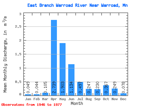
| Statistic | Jan | Feb | Mar | Apr | May | Jun | Jul | Aug | Sep | Oct | Nov | Dec | Annual |
|---|---|---|---|---|---|---|---|---|---|---|---|---|---|
| Mean | 0.05 | 0.04 | 0.10 | 2.74 | 1.90 | 1.13 | 0.50 | 0.25 | 0.23 | 0.37 | 0.25 | 0.08 | 0.68 |
| Standard Deviation | 0.03 | 0.03 | 0.08 | 1.65 | 1.86 | 1.50 | 0.77 | 0.47 | 0.35 | 0.43 | 0.30 | 0.06 | 0.33 |
| Min | 0.00 | 0.00 | 0.01 | 0.24 | 0.20 | 0.10 | 0.01 | 0.00 | 0.00 | 0.00 | 0.00 | 0.00 | 0.24 |
| Max | 0.11 | 0.11 | 0.29 | 5.36 | 6.66 | 6.19 | 2.90 | 1.96 | 1.17 | 1.45 | 1.18 | 0.17 | 1.30 |
| Coefficient of Variation | 0.69 | 0.73 | 0.76 | 0.60 | 0.98 | 1.33 | 1.55 | 1.88 | 1.52 | 1.18 | 1.21 | 0.76 | 0.48 |
 Return to R-Arctic Net Home Page