|
|
|||||||||||||||||
| Point ID: 9637 | Downloads | Plots | Site Data | Code: 05140500 |
|
|
|||||||||||||||||
| Download | |
|---|---|
| Site Descriptor Information | Site Time Series Data |
| Link to all available data | |
| View: | Time Series | All |
| Units: | m3/s |
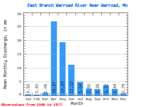
| Statistic | Jan | Feb | Mar | Apr | May | Jun | Jul | Aug | Sep | Oct | Nov | Dec | Annual |
|---|---|---|---|---|---|---|---|---|---|---|---|---|---|
| Mean | 0.49 | 0.41 | 1.06 | 26.87 | 19.29 | 11.13 | 5.04 | 2.50 | 2.26 | 3.72 | 2.44 | 0.79 | 81.72 |
| Standard Deviation | 0.34 | 0.29 | 0.81 | 16.19 | 18.85 | 14.77 | 7.82 | 4.71 | 3.42 | 4.38 | 2.95 | 0.60 | 39.35 |
| Min | 0.00 | 0.00 | 0.09 | 2.34 | 2.07 | 1.00 | 0.10 | 0.00 | 0.00 | 0.00 | 0.00 | 0.00 | 28.50 |
| Max | 1.13 | 1.00 | 2.96 | 52.54 | 67.47 | 60.73 | 29.41 | 19.82 | 11.45 | 14.66 | 11.57 | 1.75 | 155.31 |
| Coefficient of Variation | 0.69 | 0.73 | 0.76 | 0.60 | 0.98 | 1.33 | 1.55 | 1.88 | 1.52 | 1.18 | 1.21 | 0.76 | 0.48 |
 Return to R-Arctic Net Home Page