|
|
|||||||||||||||||
| Point ID: 9635 | Downloads | Plots | Site Data | Code: 05089100 |
|
|
|||||||||||||||||
| Download | |
|---|---|
| Site Descriptor Information | Site Time Series Data |
| Link to all available data | |
| View: | Time Series | All |
| Units: | mm |
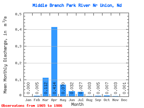
| Statistic | Jan | Feb | Mar | Apr | May | Jun | Jul | Aug | Sep | Oct | Nov | Dec | Annual |
|---|---|---|---|---|---|---|---|---|---|---|---|---|---|
| Mean | 0.00 | 0.01 | 0.11 | 0.41 | 0.07 | 0.03 | 0.03 | 0.00 | 0.01 | 0.01 | 0.00 | 0.00 | 0.06 |
| Standard Deviation | 0.00 | 0.02 | 0.17 | 0.45 | 0.12 | 0.05 | 0.05 | 0.00 | 0.01 | 0.01 | 0.00 | 0.00 | 0.04 |
| Min | 0.00 | 0.00 | 0.00 | 0.01 | 0.00 | 0.00 | 0.00 | 0.00 | 0.00 | 0.00 | 0.00 | 0.00 | 0.01 |
| Max | 0.00 | 0.08 | 0.65 | 1.70 | 0.51 | 0.17 | 0.15 | 0.01 | 0.04 | 0.04 | 0.01 | 0.01 | 0.15 |
| Coefficient of Variation | 3.17 | 4.12 | 1.47 | 1.09 | 1.73 | 1.51 | 1.73 | 0.93 | 1.76 | 1.37 | 1.28 | 1.46 | 0.68 |
 Return to R-Arctic Net Home Page