|
|
|||||||||||||||||
| Point ID: 9635 | Downloads | Plots | Site Data | Code: 05089100 |
|
|
|||||||||||||||||
| Download | |
|---|---|
| Site Descriptor Information | Site Time Series Data |
| Link to all available data | |
| View: | Time Series | All |
| Units: | m3/s |
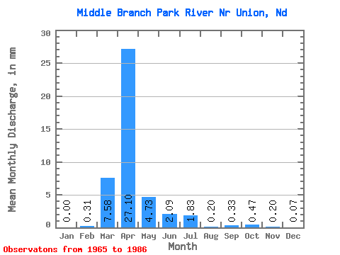
| Statistic | Jan | Feb | Mar | Apr | May | Jun | Jul | Aug | Sep | Oct | Nov | Dec | Annual |
|---|---|---|---|---|---|---|---|---|---|---|---|---|---|
| Mean | 0.01 | 0.30 | 7.57 | 27.09 | 4.72 | 2.10 | 1.82 | 0.23 | 0.30 | 0.50 | 0.23 | 0.07 | 50.37 |
| Standard Deviation | 0.03 | 1.23 | 11.14 | 29.45 | 8.17 | 3.17 | 3.16 | 0.22 | 0.52 | 0.69 | 0.29 | 0.10 | 34.15 |
| Min | 0.00 | 0.00 | 0.00 | 0.45 | 0.07 | 0.02 | 0.00 | 0.00 | 0.00 | 0.07 | 0.05 | 0.00 | 9.69 |
| Max | 0.10 | 5.07 | 44.11 | 111.29 | 34.17 | 11.35 | 10.48 | 0.67 | 2.43 | 2.76 | 1.00 | 0.32 | 122.09 |
| Coefficient of Variation | 3.17 | 4.12 | 1.47 | 1.09 | 1.73 | 1.51 | 1.73 | 0.93 | 1.76 | 1.37 | 1.28 | 1.46 | 0.68 |
 Return to R-Arctic Net Home Page