|
|
|||||||||||||||||
| Point ID: 9628 | Downloads | Plots | Site Data | Code: 05056390 |
|
|
|||||||||||||||||
| Download | |
|---|---|
| Site Descriptor Information | Site Time Series Data |
| Link to all available data | |
| View: | Time Series | All |
| Units: | mm |
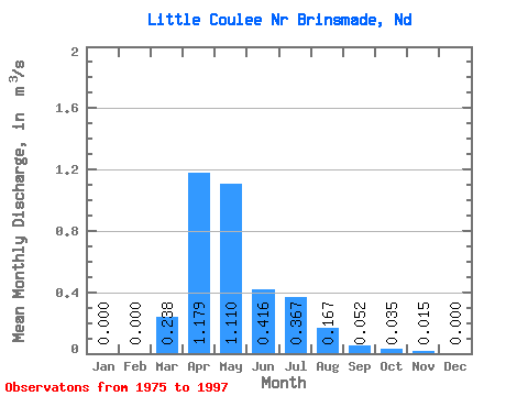
| Statistic | Jan | Feb | Mar | Apr | May | Jun | Jul | Aug | Sep | Oct | Nov | Dec | Annual |
|---|---|---|---|---|---|---|---|---|---|---|---|---|---|
| Mean | 0.00 | 0.00 | 0.24 | 1.18 | 1.11 | 0.42 | 0.37 | 0.17 | 0.05 | 0.04 | 0.01 | 0.00 | 0.22 |
| Standard Deviation | 0.00 | 0.00 | 0.55 | 2.15 | 2.33 | 0.83 | 0.87 | 0.42 | 0.14 | 0.10 | 0.04 | 0.00 | 0.40 |
| Min | 0.00 | 0.00 | 0.00 | 0.00 | 0.00 | 0.00 | 0.00 | 0.00 | 0.00 | 0.00 | 0.00 | 0.00 | 0.00 |
| Max | 0.00 | 0.00 | 2.45 | 7.95 | 8.20 | 2.88 | 3.81 | 1.71 | 0.62 | 0.28 | 0.12 | 0.00 | 1.01 |
| Coefficient of Variation | 2.83 | 2.32 | 1.82 | 2.10 | 2.00 | 2.37 | 2.53 | 2.77 | 2.82 | 2.83 | 1.82 |
 Return to R-Arctic Net Home Page