|
|
|||||||||||||||||
| Point ID: 9628 | Downloads | Plots | Site Data | Code: 05056390 |
|
|
|||||||||||||||||
| Download | |
|---|---|
| Site Descriptor Information | Site Time Series Data |
| Link to all available data | |
| View: | Time Series | All |
| Units: | m3/s |
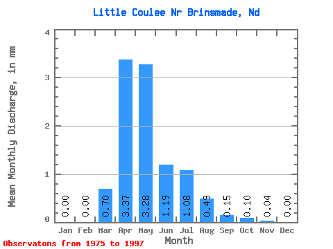
| Statistic | Jan | Feb | Mar | Apr | May | Jun | Jul | Aug | Sep | Oct | Nov | Dec | Annual |
|---|---|---|---|---|---|---|---|---|---|---|---|---|---|
| Mean | 0.00 | 0.00 | 0.70 | 3.37 | 3.28 | 1.19 | 1.08 | 0.49 | 0.15 | 0.10 | 0.04 | 0.00 | 7.61 |
| Standard Deviation | 0.00 | 0.00 | 1.63 | 6.14 | 6.88 | 2.38 | 2.57 | 1.25 | 0.41 | 0.29 | 0.12 | 0.00 | 13.86 |
| Min | 0.00 | 0.00 | 0.00 | 0.00 | 0.00 | 0.00 | 0.00 | 0.00 | 0.00 | 0.00 | 0.00 | 0.00 | 0.01 |
| Max | 0.00 | 0.01 | 7.24 | 22.74 | 24.22 | 8.25 | 11.27 | 5.04 | 1.77 | 0.83 | 0.34 | 0.00 | 35.06 |
| Coefficient of Variation | 2.83 | 2.32 | 1.82 | 2.10 | 2.00 | 2.37 | 2.53 | 2.77 | 2.82 | 2.83 | 1.82 |
 Return to R-Arctic Net Home Page