|
|
|||||||||||||||||
| Point ID: 9626 | Downloads | Plots | Site Data | Code: 05056410 |
|
|
|||||||||||||||||
| Download | |
|---|---|
| Site Descriptor Information | Site Time Series Data |
| Link to all available data | |
| View: | Time Series | All |
| Units: | mm |
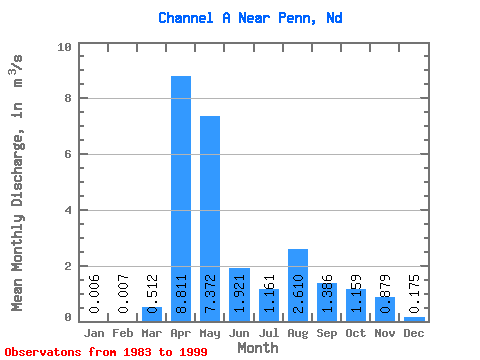
| Statistic | Jan | Feb | Mar | Apr | May | Jun | Jul | Aug | Sep | Oct | Nov | Dec | Annual |
|---|---|---|---|---|---|---|---|---|---|---|---|---|---|
| Mean | 0.01 | 0.01 | 0.51 | 8.81 | 7.37 | 1.92 | 1.16 | 2.61 | 1.39 | 1.16 | 0.88 | 0.17 | 2.02 |
| Standard Deviation | 0.01 | 0.02 | 1.00 | 10.75 | 10.89 | 3.42 | 2.73 | 8.78 | 4.81 | 1.82 | 1.08 | 0.35 | 2.50 |
| Min | 0.00 | 0.00 | 0.00 | 0.00 | 0.00 | 0.00 | 0.00 | 0.00 | 0.00 | 0.00 | 0.00 | 0.00 | 0.00 |
| Max | 0.05 | 0.08 | 3.68 | 33.34 | 38.62 | 12.04 | 10.58 | 35.15 | 19.37 | 5.21 | 3.73 | 1.26 | 7.55 |
| Coefficient of Variation | 2.37 | 2.79 | 1.95 | 1.22 | 1.48 | 1.78 | 2.36 | 3.37 | 3.47 | 1.57 | 1.23 | 1.98 | 1.23 |
 Return to R-Arctic Net Home Page