|
|
|||||||||||||||||
| Point ID: 9626 | Downloads | Plots | Site Data | Code: 05056410 |
|
|
|||||||||||||||||
| Download | |
|---|---|
| Site Descriptor Information | Site Time Series Data |
| Link to all available data | |
| View: | Time Series | All |
| Units: | m3/s |
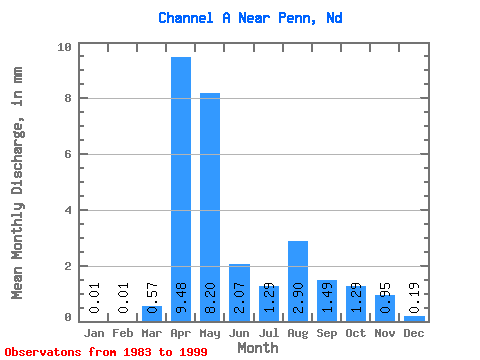
| Statistic | Jan | Feb | Mar | Apr | May | Jun | Jul | Aug | Sep | Oct | Nov | Dec | Annual |
|---|---|---|---|---|---|---|---|---|---|---|---|---|---|
| Mean | 0.01 | 0.01 | 0.57 | 9.48 | 8.20 | 2.07 | 1.29 | 2.90 | 1.49 | 1.29 | 0.95 | 0.20 | 26.53 |
| Standard Deviation | 0.02 | 0.02 | 1.11 | 11.57 | 12.11 | 3.68 | 3.04 | 9.77 | 5.17 | 2.02 | 1.17 | 0.39 | 32.70 |
| Min | 0.00 | 0.00 | 0.00 | 0.00 | 0.00 | 0.00 | 0.00 | 0.00 | 0.00 | 0.00 | 0.00 | 0.00 | 0.02 |
| Max | 0.06 | 0.08 | 4.09 | 35.88 | 42.93 | 12.95 | 11.76 | 39.08 | 20.85 | 5.79 | 4.01 | 1.40 | 98.89 |
| Coefficient of Variation | 2.37 | 2.79 | 1.95 | 1.22 | 1.48 | 1.78 | 2.36 | 3.37 | 3.47 | 1.57 | 1.23 | 1.98 | 1.23 |
 Return to R-Arctic Net Home Page