|
|
|||||||||||||||||
| Point ID: 9621 | Downloads | Plots | Site Data | Code: 05128500 |
|
|
|||||||||||||||||
| Download | |
|---|---|
| Site Descriptor Information | Site Time Series Data |
| Link to all available data | |
| View: | Time Series | All |
| Units: | mm |
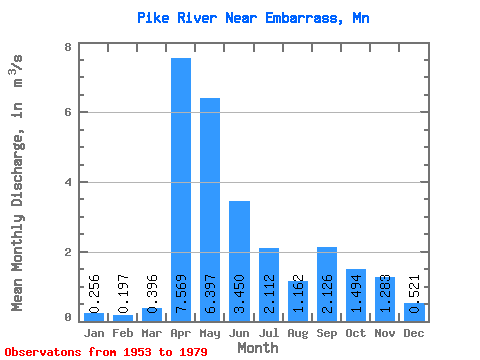
| Statistic | Jan | Feb | Mar | Apr | May | Jun | Jul | Aug | Sep | Oct | Nov | Dec | Annual |
|---|---|---|---|---|---|---|---|---|---|---|---|---|---|
| Mean | 0.26 | 0.20 | 0.40 | 7.57 | 6.40 | 3.45 | 2.11 | 1.16 | 2.13 | 1.49 | 1.28 | 0.52 | 2.20 |
| Standard Deviation | 0.15 | 0.12 | 0.21 | 4.42 | 3.54 | 1.38 | 1.86 | 1.34 | 2.29 | 1.32 | 0.87 | 0.36 | 0.45 |
| Min | 0.06 | 0.02 | 0.12 | 0.61 | 0.86 | 0.73 | 0.24 | 0.14 | 0.20 | 0.41 | 0.39 | 0.10 | 1.47 |
| Max | 0.56 | 0.49 | 0.90 | 16.02 | 12.54 | 5.42 | 6.14 | 5.32 | 8.08 | 5.25 | 3.45 | 1.63 | 3.12 |
| Coefficient of Variation | 0.60 | 0.60 | 0.53 | 0.58 | 0.55 | 0.40 | 0.88 | 1.15 | 1.08 | 0.88 | 0.68 | 0.70 | 0.20 |
 Return to R-Arctic Net Home Page