|
|
|||||||||||||||||
| Point ID: 9621 | Downloads | Plots | Site Data | Code: 05128500 |
|
|
|||||||||||||||||
| Download | |
|---|---|
| Site Descriptor Information | Site Time Series Data |
| Link to all available data | |
| View: | Time Series | All |
| Units: | m3/s |
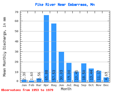
| Statistic | Jan | Feb | Mar | Apr | May | Jun | Jul | Aug | Sep | Oct | Nov | Dec | Annual |
|---|---|---|---|---|---|---|---|---|---|---|---|---|---|
| Mean | 2.30 | 1.61 | 3.56 | 65.88 | 57.52 | 30.03 | 19.00 | 10.45 | 18.50 | 13.44 | 11.16 | 4.68 | 233.56 |
| Standard Deviation | 1.38 | 0.97 | 1.90 | 38.49 | 31.84 | 12.03 | 16.73 | 12.04 | 19.90 | 11.85 | 7.55 | 3.28 | 47.16 |
| Min | 0.57 | 0.19 | 1.04 | 5.33 | 7.70 | 6.33 | 2.12 | 1.26 | 1.75 | 3.66 | 3.43 | 0.85 | 156.10 |
| Max | 5.06 | 3.98 | 8.13 | 139.48 | 112.72 | 47.15 | 55.22 | 47.81 | 70.30 | 47.21 | 30.00 | 14.63 | 330.36 |
| Coefficient of Variation | 0.60 | 0.60 | 0.53 | 0.58 | 0.55 | 0.40 | 0.88 | 1.15 | 1.08 | 0.88 | 0.68 | 0.70 | 0.20 |
 Return to R-Arctic Net Home Page