|
|
|||||||||||||||||
| Point ID: 9617 | Downloads | Plots | Site Data | Code: 05101500 |
|
|
|||||||||||||||||
| Download | |
|---|---|
| Site Descriptor Information | Site Time Series Data |
| Link to all available data | |
| View: | Time Series | All |
| Units: | mm |
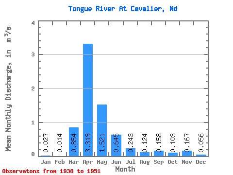
| Statistic | Jan | Feb | Mar | Apr | May | Jun | Jul | Aug | Sep | Oct | Nov | Dec | Annual |
|---|---|---|---|---|---|---|---|---|---|---|---|---|---|
| Mean | 0.03 | 0.01 | 0.85 | 3.32 | 1.52 | 0.65 | 0.24 | 0.12 | 0.16 | 0.10 | 0.17 | 0.06 | 0.62 |
| Standard Deviation | 0.03 | 0.02 | 1.54 | 2.41 | 3.05 | 0.74 | 0.27 | 0.17 | 0.21 | 0.11 | 0.34 | 0.07 | 0.42 |
| Min | 0.00 | 0.00 | 0.00 | 0.40 | 0.08 | 0.04 | 0.00 | 0.00 | 0.00 | 0.00 | 0.00 | 0.00 | 0.04 |
| Max | 0.10 | 0.08 | 5.22 | 7.73 | 11.49 | 2.78 | 0.88 | 0.59 | 0.67 | 0.40 | 1.28 | 0.28 | 1.56 |
| Coefficient of Variation | 1.13 | 1.58 | 1.80 | 0.73 | 2.00 | 1.16 | 1.10 | 1.33 | 1.33 | 1.04 | 2.03 | 1.33 | 0.68 |
 Return to R-Arctic Net Home Page