|
|
|||||||||||||||||
| Point ID: 9617 | Downloads | Plots | Site Data | Code: 05101500 |
|
|
|||||||||||||||||
| Download | |
|---|---|
| Site Descriptor Information | Site Time Series Data |
| Link to all available data | |
| View: | Time Series | All |
| Units: | m3/s |
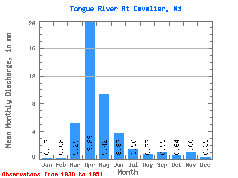
| Statistic | Jan | Feb | Mar | Apr | May | Jun | Jul | Aug | Sep | Oct | Nov | Dec | Annual |
|---|---|---|---|---|---|---|---|---|---|---|---|---|---|
| Mean | 0.17 | 0.08 | 5.29 | 19.89 | 9.42 | 3.87 | 1.50 | 0.77 | 0.95 | 0.64 | 1.00 | 0.35 | 45.19 |
| Standard Deviation | 0.19 | 0.13 | 9.53 | 14.46 | 18.88 | 4.46 | 1.65 | 1.02 | 1.26 | 0.66 | 2.03 | 0.46 | 30.72 |
| Min | 0.00 | 0.00 | 0.00 | 2.41 | 0.50 | 0.21 | 0.01 | 0.00 | 0.00 | 0.00 | 0.00 | 0.00 | 3.26 |
| Max | 0.64 | 0.45 | 32.34 | 46.33 | 71.16 | 16.66 | 5.42 | 3.67 | 4.00 | 2.50 | 7.69 | 1.75 | 114.17 |
| Coefficient of Variation | 1.13 | 1.58 | 1.80 | 0.73 | 2.00 | 1.16 | 1.10 | 1.33 | 1.33 | 1.04 | 2.03 | 1.33 | 0.68 |
 Return to R-Arctic Net Home Page