|
|
|||||||||||||||||
| Point ID: 9602 | Downloads | Plots | Site Data | Code: 05040000 |
|
|
|||||||||||||||||
| Download | |
|---|---|
| Site Descriptor Information | Site Time Series Data |
| Link to all available data | |
| View: | Time Series | All |
| Units: | mm |
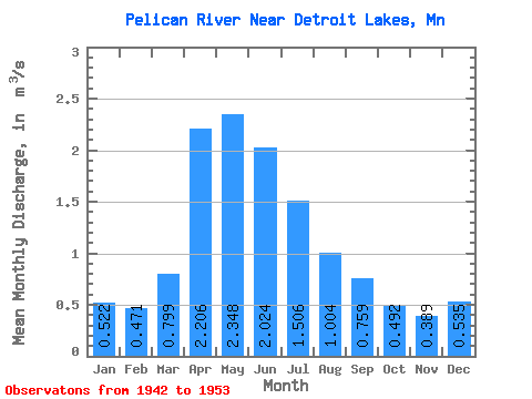
| Statistic | Jan | Feb | Mar | Apr | May | Jun | Jul | Aug | Sep | Oct | Nov | Dec | Annual |
|---|---|---|---|---|---|---|---|---|---|---|---|---|---|
| Mean | 0.52 | 0.47 | 0.80 | 2.21 | 2.35 | 2.02 | 1.51 | 1.00 | 0.76 | 0.49 | 0.39 | 0.54 | 1.02 |
| Standard Deviation | 0.53 | 0.40 | 0.61 | 0.90 | 1.08 | 1.62 | 1.07 | 1.23 | 1.07 | 0.64 | 0.50 | 0.62 | 0.37 |
| Min | 0.01 | 0.01 | 0.03 | 0.84 | 0.79 | 0.26 | 0.12 | 0.01 | 0.01 | 0.01 | 0.00 | 0.01 | 0.34 |
| Max | 1.57 | 1.17 | 2.19 | 3.71 | 4.72 | 5.61 | 3.34 | 4.17 | 3.15 | 1.98 | 1.31 | 1.60 | 1.57 |
| Coefficient of Variation | 1.02 | 0.85 | 0.76 | 0.41 | 0.46 | 0.80 | 0.71 | 1.23 | 1.41 | 1.29 | 1.28 | 1.16 | 0.36 |
 Return to R-Arctic Net Home Page