|
|
|||||||||||||||||
| Point ID: 9602 | Downloads | Plots | Site Data | Code: 05040000 |
|
|
|||||||||||||||||
| Download | |
|---|---|
| Site Descriptor Information | Site Time Series Data |
| Link to all available data | |
| View: | Time Series | All |
| Units: | m3/s |
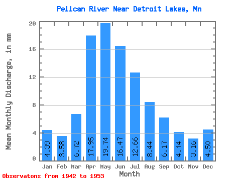
| Statistic | Jan | Feb | Mar | Apr | May | Jun | Jul | Aug | Sep | Oct | Nov | Dec | Annual |
|---|---|---|---|---|---|---|---|---|---|---|---|---|---|
| Mean | 4.39 | 3.61 | 6.72 | 17.94 | 19.74 | 16.47 | 12.66 | 8.44 | 6.17 | 4.13 | 3.16 | 4.50 | 101.19 |
| Standard Deviation | 4.49 | 3.08 | 5.11 | 7.34 | 9.06 | 13.18 | 9.00 | 10.36 | 8.70 | 5.34 | 4.06 | 5.23 | 36.74 |
| Min | 0.05 | 0.09 | 0.25 | 6.86 | 6.65 | 2.09 | 1.01 | 0.07 | 0.05 | 0.04 | 0.03 | 0.06 | 33.89 |
| Max | 13.19 | 8.97 | 18.38 | 30.14 | 39.70 | 45.62 | 28.04 | 35.04 | 25.64 | 16.67 | 10.66 | 13.44 | 156.05 |
| Coefficient of Variation | 1.02 | 0.85 | 0.76 | 0.41 | 0.46 | 0.80 | 0.71 | 1.23 | 1.41 | 1.29 | 1.28 | 1.16 | 0.36 |
 Return to R-Arctic Net Home Page