|
|
|||||||||||||||||
| Point ID: 9591 | Downloads | Plots | Site Data | Code: 05124500 |
|
|
|||||||||||||||||
| Download | |
|---|---|
| Site Descriptor Information | Site Time Series Data |
| Link to all available data | |
| View: | Time Series | All |
| Units: | mm |
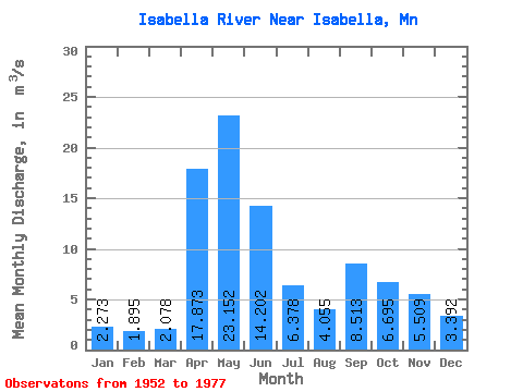
| Statistic | Jan | Feb | Mar | Apr | May | Jun | Jul | Aug | Sep | Oct | Nov | Dec | Annual |
|---|---|---|---|---|---|---|---|---|---|---|---|---|---|
| Mean | 2.27 | 1.90 | 2.08 | 17.87 | 23.15 | 14.20 | 6.38 | 4.05 | 8.51 | 6.70 | 5.51 | 3.39 | 8.04 |
| Standard Deviation | 0.70 | 0.56 | 0.52 | 11.93 | 15.82 | 5.17 | 3.98 | 2.68 | 8.50 | 9.01 | 3.30 | 1.13 | 1.72 |
| Min | 0.84 | 0.93 | 1.50 | 3.75 | 3.51 | 5.17 | 1.75 | 1.09 | 0.74 | 0.96 | 0.98 | 0.87 | 5.65 |
| Max | 3.15 | 2.59 | 2.99 | 45.58 | 50.80 | 23.08 | 14.96 | 9.72 | 29.20 | 32.73 | 13.32 | 4.81 | 10.21 |
| Coefficient of Variation | 0.31 | 0.30 | 0.25 | 0.67 | 0.68 | 0.36 | 0.62 | 0.66 | 1.00 | 1.35 | 0.60 | 0.33 | 0.21 |
 Return to R-Arctic Net Home Page