|
|
|||||||||||||||||
| Point ID: 9591 | Downloads | Plots | Site Data | Code: 05124500 |
|
|
|||||||||||||||||
| Download | |
|---|---|
| Site Descriptor Information | Site Time Series Data |
| Link to all available data | |
| View: | Time Series | All |
| Units: | m3/s |
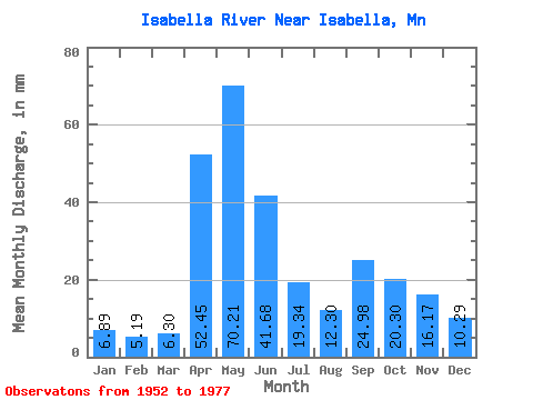
| Statistic | Jan | Feb | Mar | Apr | May | Jun | Jul | Aug | Sep | Oct | Nov | Dec | Annual |
|---|---|---|---|---|---|---|---|---|---|---|---|---|---|
| Mean | 6.89 | 5.24 | 6.30 | 52.45 | 70.20 | 41.68 | 19.34 | 12.30 | 24.98 | 20.30 | 16.17 | 10.29 | 287.32 |
| Standard Deviation | 2.12 | 1.55 | 1.57 | 35.01 | 47.98 | 15.17 | 12.08 | 8.12 | 24.95 | 27.32 | 9.68 | 3.41 | 61.47 |
| Min | 2.55 | 2.58 | 4.53 | 11.02 | 10.64 | 15.16 | 5.31 | 3.30 | 2.19 | 2.92 | 2.86 | 2.64 | 201.91 |
| Max | 9.55 | 7.15 | 9.08 | 133.77 | 154.03 | 67.73 | 45.35 | 29.46 | 85.69 | 99.25 | 39.10 | 14.57 | 364.99 |
| Coefficient of Variation | 0.31 | 0.30 | 0.25 | 0.67 | 0.68 | 0.36 | 0.62 | 0.66 | 1.00 | 1.35 | 0.60 | 0.33 | 0.21 |
 Return to R-Arctic Net Home Page