|
|
|||||||||||||||||
| Point ID: 9589 | Downloads | Plots | Site Data | Code: 05095500 |
|
|
|||||||||||||||||
| Download | |
|---|---|
| Site Descriptor Information | Site Time Series Data |
| Link to all available data | |
| View: | Time Series | All |
| Units: | mm |
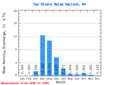
| Statistic | Jan | Feb | Mar | Apr | May | Jun | Jul | Aug | Sep | Oct | Nov | Dec | Annual |
|---|---|---|---|---|---|---|---|---|---|---|---|---|---|
| Mean | 0.06 | 0.06 | 1.41 | 12.34 | 10.71 | 5.62 | 2.27 | 0.60 | 0.50 | 0.80 | 0.32 | 0.14 | 2.95 |
| Standard Deviation | 0.08 | 0.07 | 2.94 | 8.62 | 20.71 | 6.52 | 3.59 | 0.92 | 0.84 | 1.45 | 0.28 | 0.13 | 3.30 |
| Min | 0.00 | 0.00 | 0.01 | 0.85 | 0.19 | 0.12 | 0.03 | 0.03 | 0.00 | 0.01 | 0.02 | 0.01 | 0.35 |
| Max | 0.24 | 0.19 | 8.47 | 25.47 | 71.43 | 17.34 | 10.03 | 3.05 | 2.41 | 4.76 | 0.73 | 0.34 | 10.99 |
| Coefficient of Variation | 1.33 | 1.13 | 2.08 | 0.70 | 1.93 | 1.16 | 1.58 | 1.52 | 1.68 | 1.80 | 0.87 | 0.88 | 1.12 |
 Return to R-Arctic Net Home Page