|
|
|||||||||||||||||
| Point ID: 9589 | Downloads | Plots | Site Data | Code: 05095500 |
|
|
|||||||||||||||||
| Download | |
|---|---|
| Site Descriptor Information | Site Time Series Data |
| Link to all available data | |
| View: | Time Series | All |
| Units: | m3/s |
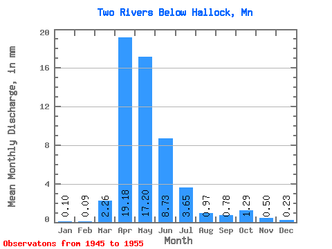
| Statistic | Jan | Feb | Mar | Apr | May | Jun | Jul | Aug | Sep | Oct | Nov | Dec | Annual |
|---|---|---|---|---|---|---|---|---|---|---|---|---|---|
| Mean | 0.10 | 0.09 | 2.26 | 19.18 | 17.20 | 8.73 | 3.65 | 0.97 | 0.78 | 1.29 | 0.50 | 0.23 | 55.73 |
| Standard Deviation | 0.14 | 0.10 | 4.71 | 13.39 | 33.26 | 10.13 | 5.76 | 1.48 | 1.31 | 2.32 | 0.43 | 0.20 | 62.43 |
| Min | 0.00 | 0.00 | 0.02 | 1.32 | 0.31 | 0.20 | 0.04 | 0.04 | 0.00 | 0.01 | 0.03 | 0.01 | 6.58 |
| Max | 0.38 | 0.27 | 13.60 | 39.58 | 114.69 | 26.95 | 16.11 | 4.89 | 3.74 | 7.65 | 1.14 | 0.55 | 207.98 |
| Coefficient of Variation | 1.33 | 1.13 | 2.08 | 0.70 | 1.93 | 1.16 | 1.58 | 1.52 | 1.68 | 1.80 | 0.87 | 0.88 | 1.12 |
 Return to R-Arctic Net Home Page