|
|
|||||||||||||||||
| Point ID: 9566 | Downloads | Plots | Site Data | Code: 05125550 |
|
|
|||||||||||||||||
| Download | |
|---|---|
| Site Descriptor Information | Site Time Series Data |
| Link to all available data | |
| View: | Time Series | All |
| Units: | mm |
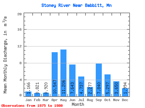
| Statistic | Jan | Feb | Mar | Apr | May | Jun | Jul | Aug | Sep | Oct | Nov | Dec | Annual |
|---|---|---|---|---|---|---|---|---|---|---|---|---|---|
| Mean | 1.17 | 0.82 | 0.92 | 10.55 | 11.21 | 7.64 | 4.74 | 2.28 | 7.84 | 5.30 | 3.65 | 1.99 | 5.19 |
| Standard Deviation | 0.64 | 0.36 | 0.31 | 10.68 | 10.28 | 4.31 | 3.39 | 2.21 | 5.67 | 5.97 | 2.75 | 1.50 | 0.82 |
| Min | 0.28 | 0.28 | 0.63 | 1.63 | 1.83 | 2.73 | 1.19 | 0.47 | 0.21 | 0.24 | 0.33 | 0.30 | 4.17 |
| Max | 2.01 | 1.19 | 1.41 | 28.62 | 27.29 | 13.78 | 10.11 | 6.65 | 15.44 | 16.80 | 6.92 | 4.14 | 5.92 |
| Coefficient of Variation | 0.55 | 0.43 | 0.34 | 1.01 | 0.92 | 0.56 | 0.72 | 0.97 | 0.72 | 1.13 | 0.75 | 0.75 | 0.16 |
 Return to R-Arctic Net Home Page