|
|
|||||||||||||||||
| Point ID: 9566 | Downloads | Plots | Site Data | Code: 05125550 |
|
|
|||||||||||||||||
| Download | |
|---|---|
| Site Descriptor Information | Site Time Series Data |
| Link to all available data | |
| View: | Time Series | All |
| Units: | m3/s |
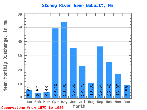
| Statistic | Jan | Feb | Mar | Apr | May | Jun | Jul | Aug | Sep | Oct | Nov | Dec | Annual |
|---|---|---|---|---|---|---|---|---|---|---|---|---|---|
| Mean | 5.61 | 3.60 | 4.42 | 49.10 | 53.90 | 35.58 | 22.78 | 10.95 | 36.50 | 25.48 | 16.99 | 9.59 | 294.40 |
| Standard Deviation | 3.09 | 1.56 | 1.50 | 49.71 | 49.43 | 20.06 | 16.30 | 10.64 | 26.39 | 28.73 | 12.81 | 7.22 | 46.63 |
| Min | 1.33 | 1.22 | 3.03 | 7.58 | 8.80 | 12.70 | 5.71 | 2.26 | 0.98 | 1.14 | 1.53 | 1.44 | 236.16 |
| Max | 9.65 | 5.21 | 6.76 | 133.23 | 131.26 | 64.14 | 48.65 | 32.00 | 71.86 | 80.81 | 32.24 | 19.92 | 335.73 |
| Coefficient of Variation | 0.55 | 0.43 | 0.34 | 1.01 | 0.92 | 0.56 | 0.72 | 0.97 | 0.72 | 1.13 | 0.75 | 0.75 | 0.16 |
 Return to R-Arctic Net Home Page