|
|
|||||||||||||||||
| Point ID: 9521 | Downloads | Plots | Site Data | Code: 15292000 |
|
|
|||||||||||||||||
| Download | |
|---|---|
| Site Descriptor Information | Site Time Series Data |
| Link to all available data | |
| View: | Time Series | All |
| Units: | mm |
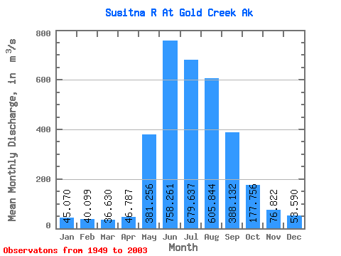
| Statistic | Jan | Feb | Mar | Apr | May | Jun | Jul | Aug | Sep | Oct | Nov | Dec | Annual |
|---|---|---|---|---|---|---|---|---|---|---|---|---|---|
| Mean | 45.07 | 40.10 | 36.63 | 46.79 | 381.26 | 758.26 | 679.64 | 605.84 | 388.13 | 177.76 | 76.82 | 53.59 | 275.57 |
| Standard Deviation | 11.88 | 11.15 | 10.63 | 18.23 | 129.31 | 194.90 | 118.98 | 132.79 | 120.53 | 53.79 | 21.50 | 14.47 | 37.08 |
| Min | 20.51 | 20.48 | 20.20 | 21.10 | 106.05 | 439.01 | 453.25 | 251.43 | 144.23 | 88.45 | 34.41 | 24.53 | 154.81 |
| Max | 69.42 | 63.51 | 53.80 | 120.35 | 725.83 | 1432.17 | 974.10 | 1072.39 | 750.59 | 358.93 | 152.73 | 92.41 | 364.10 |
| Coefficient of Variation | 0.26 | 0.28 | 0.29 | 0.39 | 0.34 | 0.26 | 0.17 | 0.22 | 0.31 | 0.30 | 0.28 | 0.27 | 0.14 |
 Return to R-Arctic Net Home Page