|
|
|||||||||||||||||
| Point ID: 9521 | Downloads | Plots | Site Data | Code: 15292000 |
|
|
|||||||||||||||||
| Download | |
|---|---|
| Site Descriptor Information | Site Time Series Data |
| Link to all available data | |
| View: | Time Series | All |
| Units: | m3/s |
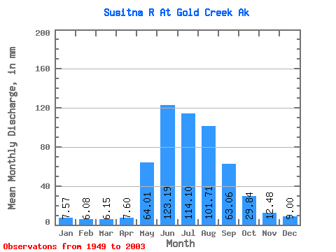
| Statistic | Jan | Feb | Mar | Apr | May | Jun | Jul | Aug | Sep | Oct | Nov | Dec | Annual |
|---|---|---|---|---|---|---|---|---|---|---|---|---|---|
| Mean | 7.56 | 6.13 | 6.15 | 7.60 | 64.00 | 123.19 | 114.08 | 101.69 | 63.06 | 29.84 | 12.48 | 8.99 | 545.12 |
| Standard Deviation | 2.00 | 1.71 | 1.79 | 2.96 | 21.70 | 31.66 | 19.97 | 22.29 | 19.58 | 9.03 | 3.49 | 2.43 | 73.34 |
| Min | 3.44 | 3.13 | 3.39 | 3.43 | 17.80 | 71.32 | 76.08 | 42.20 | 23.43 | 14.85 | 5.59 | 4.12 | 306.23 |
| Max | 11.65 | 9.71 | 9.03 | 19.55 | 121.83 | 232.68 | 163.51 | 180.00 | 121.94 | 60.25 | 24.81 | 15.51 | 720.24 |
| Coefficient of Variation | 0.26 | 0.28 | 0.29 | 0.39 | 0.34 | 0.26 | 0.17 | 0.22 | 0.31 | 0.30 | 0.28 | 0.27 | 0.14 |
 Return to R-Arctic Net Home Page