|
|
|||||||||||||||||
| Point ID: 9518 | Downloads | Plots | Site Data | Code: 15291000 |
|
|
|||||||||||||||||
| Download | |
|---|---|
| Site Descriptor Information | Site Time Series Data |
| Link to all available data | |
| View: | Time Series | All |
| Units: | mm |
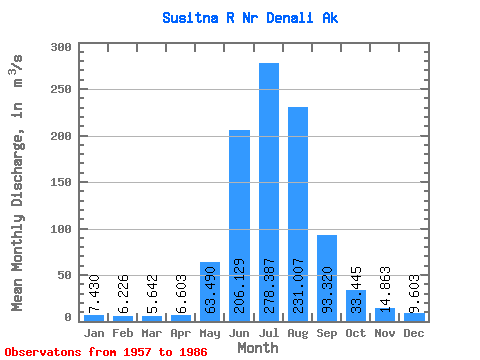
| Statistic | Jan | Feb | Mar | Apr | May | Jun | Jul | Aug | Sep | Oct | Nov | Dec | Annual |
|---|---|---|---|---|---|---|---|---|---|---|---|---|---|
| Mean | 7.43 | 6.23 | 5.64 | 6.60 | 63.49 | 206.13 | 278.39 | 231.01 | 93.32 | 33.45 | 14.86 | 9.60 | 78.49 |
| Standard Deviation | 2.43 | 2.00 | 1.90 | 2.31 | 26.18 | 50.66 | 42.67 | 50.24 | 33.71 | 11.44 | 4.46 | 3.15 | 8.50 |
| Min | 3.16 | 2.29 | 1.18 | 1.22 | 17.80 | 131.58 | 191.31 | 110.97 | 51.58 | 14.95 | 8.21 | 4.79 | 61.44 |
| Max | 12.56 | 9.35 | 8.24 | 11.75 | 145.12 | 345.61 | 374.86 | 339.98 | 196.94 | 61.29 | 24.87 | 16.28 | 93.16 |
| Coefficient of Variation | 0.33 | 0.32 | 0.34 | 0.35 | 0.41 | 0.25 | 0.15 | 0.22 | 0.36 | 0.34 | 0.30 | 0.33 | 0.11 |
 Return to R-Arctic Net Home Page