|
|
|||||||||||||||||
| Point ID: 9518 | Downloads | Plots | Site Data | Code: 15291000 |
|
|
|||||||||||||||||
| Download | |
|---|---|
| Site Descriptor Information | Site Time Series Data |
| Link to all available data | |
| View: | Time Series | All |
| Units: | m3/s |
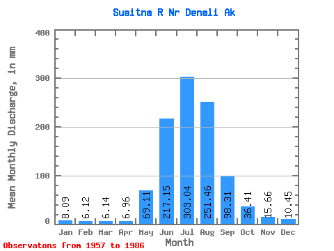
| Statistic | Jan | Feb | Mar | Apr | May | Jun | Jul | Aug | Sep | Oct | Nov | Dec | Annual |
|---|---|---|---|---|---|---|---|---|---|---|---|---|---|
| Mean | 8.09 | 6.17 | 6.14 | 6.96 | 69.10 | 217.15 | 303.00 | 251.43 | 98.31 | 36.40 | 15.66 | 10.45 | 1006.81 |
| Standard Deviation | 2.64 | 1.98 | 2.06 | 2.44 | 28.50 | 53.37 | 46.45 | 54.69 | 35.51 | 12.45 | 4.69 | 3.43 | 108.97 |
| Min | 3.44 | 2.27 | 1.29 | 1.28 | 19.38 | 138.61 | 208.22 | 120.78 | 54.34 | 16.27 | 8.65 | 5.21 | 788.02 |
| Max | 13.67 | 9.28 | 8.97 | 12.38 | 157.95 | 364.08 | 408.00 | 370.03 | 207.47 | 66.71 | 26.20 | 17.72 | 1194.86 |
| Coefficient of Variation | 0.33 | 0.32 | 0.34 | 0.35 | 0.41 | 0.25 | 0.15 | 0.22 | 0.36 | 0.34 | 0.30 | 0.33 | 0.11 |
 Return to R-Arctic Net Home Page