|
|
|||||||||||||||||
| Point ID: 9482 | Downloads | Plots | Site Data | Code: 15294450 |
|
|
|||||||||||||||||
| Download | |
|---|---|
| Site Descriptor Information | Site Time Series Data |
| Link to all available data | |
| View: | Time Series | All |
| Units: | mm |
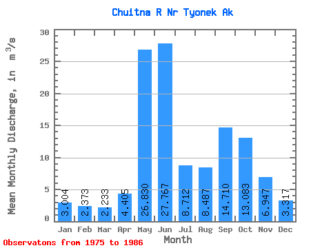
| Statistic | Jan | Feb | Mar | Apr | May | Jun | Jul | Aug | Sep | Oct | Nov | Dec | Annual |
|---|---|---|---|---|---|---|---|---|---|---|---|---|---|
| Mean | 3.00 | 2.37 | 2.23 | 4.41 | 26.83 | 27.77 | 8.71 | 8.49 | 14.71 | 13.08 | 6.95 | 3.32 | 10.26 |
| Standard Deviation | 0.88 | 0.57 | 0.43 | 2.10 | 10.22 | 15.85 | 4.76 | 4.66 | 8.01 | 5.63 | 6.83 | 1.90 | 2.69 |
| Min | 1.85 | 1.72 | 1.70 | 1.92 | 8.34 | 8.17 | 2.79 | 3.55 | 5.22 | 9.21 | 2.82 | 1.77 | 7.35 |
| Max | 4.80 | 3.58 | 2.97 | 7.39 | 42.15 | 61.99 | 17.03 | 18.90 | 30.09 | 28.41 | 25.70 | 8.62 | 14.33 |
| Coefficient of Variation | 0.29 | 0.24 | 0.20 | 0.48 | 0.38 | 0.57 | 0.55 | 0.55 | 0.55 | 0.43 | 0.98 | 0.57 | 0.26 |
 Return to R-Arctic Net Home Page