|
|
|||||||||||||||||
| Point ID: 9482 | Downloads | Plots | Site Data | Code: 15294450 |
|
|
|||||||||||||||||
| Download | |
|---|---|
| Site Descriptor Information | Site Time Series Data |
| Link to all available data | |
| View: | Time Series | All |
| Units: | m3/s |
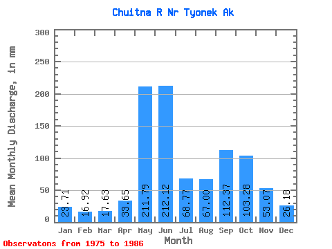
| Statistic | Jan | Feb | Mar | Apr | May | Jun | Jul | Aug | Sep | Oct | Nov | Dec | Annual |
|---|---|---|---|---|---|---|---|---|---|---|---|---|---|
| Mean | 23.71 | 17.07 | 17.63 | 33.65 | 211.76 | 212.12 | 68.76 | 66.98 | 112.38 | 103.26 | 53.07 | 26.18 | 953.88 |
| Standard Deviation | 6.98 | 4.13 | 3.44 | 16.06 | 80.67 | 121.05 | 37.57 | 36.77 | 61.20 | 44.47 | 52.13 | 15.01 | 250.67 |
| Min | 14.60 | 12.38 | 13.41 | 14.69 | 65.81 | 62.39 | 22.03 | 28.01 | 39.90 | 72.66 | 21.55 | 13.99 | 684.08 |
| Max | 37.85 | 25.75 | 23.47 | 56.46 | 332.65 | 473.52 | 134.41 | 149.18 | 229.88 | 224.26 | 196.32 | 68.04 | 1333.31 |
| Coefficient of Variation | 0.29 | 0.24 | 0.20 | 0.48 | 0.38 | 0.57 | 0.55 | 0.55 | 0.55 | 0.43 | 0.98 | 0.57 | 0.26 |
 Return to R-Arctic Net Home Page