|
|
|||||||||||||||||
| Point ID: 9475 | Downloads | Plots | Site Data | Code: 15258000 |
|
|
|||||||||||||||||
| Download | |
|---|---|
| Site Descriptor Information | Site Time Series Data |
| Link to all available data | |
| View: | Time Series | All |
| Units: | mm |
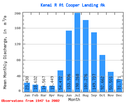
| Statistic | Jan | Feb | Mar | Apr | May | Jun | Jul | Aug | Sep | Oct | Nov | Dec | Annual |
|---|---|---|---|---|---|---|---|---|---|---|---|---|---|
| Mean | 23.44 | 18.63 | 14.57 | 15.45 | 54.47 | 153.94 | 198.27 | 180.28 | 149.74 | 92.66 | 50.50 | 31.77 | 81.98 |
| Standard Deviation | 13.12 | 10.89 | 6.19 | 6.10 | 20.88 | 38.84 | 33.45 | 37.56 | 59.05 | 42.66 | 23.88 | 16.67 | 14.38 |
| Min | 8.79 | 7.11 | 5.89 | 7.42 | 18.63 | 92.55 | 137.86 | 103.39 | 74.44 | 35.78 | 18.51 | 10.29 | 56.77 |
| Max | 79.50 | 58.49 | 31.78 | 30.32 | 99.35 | 283.39 | 296.81 | 323.74 | 325.49 | 253.59 | 138.10 | 98.23 | 118.49 |
| Coefficient of Variation | 0.56 | 0.58 | 0.42 | 0.40 | 0.38 | 0.25 | 0.17 | 0.21 | 0.39 | 0.46 | 0.47 | 0.53 | 0.17 |
 Return to R-Arctic Net Home Page