|
|
|||||||||||||||||
| Point ID: 9475 | Downloads | Plots | Site Data | Code: 15258000 |
|
|
|||||||||||||||||
| Download | |
|---|---|
| Site Descriptor Information | Site Time Series Data |
| Link to all available data | |
| View: | Time Series | All |
| Units: | m3/s |
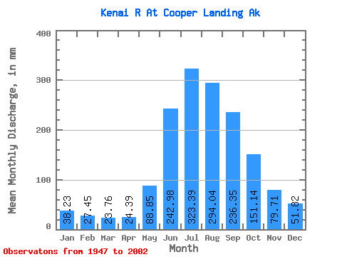
| Statistic | Jan | Feb | Mar | Apr | May | Jun | Jul | Aug | Sep | Oct | Nov | Dec | Annual |
|---|---|---|---|---|---|---|---|---|---|---|---|---|---|
| Mean | 38.22 | 27.69 | 23.76 | 24.39 | 88.83 | 242.98 | 323.34 | 294.00 | 236.35 | 151.12 | 79.71 | 51.81 | 1575.68 |
| Standard Deviation | 21.39 | 16.18 | 10.10 | 9.63 | 34.06 | 61.30 | 54.55 | 61.25 | 93.21 | 69.58 | 37.70 | 27.18 | 276.39 |
| Min | 14.33 | 10.56 | 9.61 | 11.71 | 30.39 | 146.09 | 224.82 | 168.62 | 117.51 | 58.36 | 29.21 | 16.79 | 1090.98 |
| Max | 129.65 | 86.92 | 51.83 | 47.86 | 162.02 | 447.31 | 484.04 | 527.96 | 513.78 | 413.57 | 217.99 | 160.20 | 2277.28 |
| Coefficient of Variation | 0.56 | 0.58 | 0.42 | 0.40 | 0.38 | 0.25 | 0.17 | 0.21 | 0.39 | 0.46 | 0.47 | 0.53 | 0.17 |
 Return to R-Arctic Net Home Page