|
|
|||||||||||||||||
| Point ID: 9459 | Downloads | Plots | Site Data | Code: 15239050 |
|
|
|||||||||||||||||
| Download | |
|---|---|
| Site Descriptor Information | Site Time Series Data |
| Link to all available data | |
| View: | Time Series | All |
| Units: | mm |
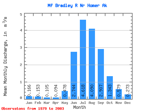
| Statistic | Jan | Feb | Mar | Apr | May | Jun | Jul | Aug | Sep | Oct | Nov | Dec | Annual |
|---|---|---|---|---|---|---|---|---|---|---|---|---|---|
| Mean | 0.17 | 0.15 | 0.10 | 0.09 | 0.48 | 2.74 | 4.62 | 4.09 | 2.91 | 1.34 | 0.58 | 0.27 | 1.45 |
| Standard Deviation | 0.08 | 0.12 | 0.03 | 0.02 | 0.28 | 0.70 | 0.83 | 0.87 | 1.19 | 0.95 | 0.58 | 0.24 | 0.25 |
| Min | 0.11 | 0.08 | 0.04 | 0.07 | 0.15 | 1.27 | 3.15 | 2.46 | 1.09 | 0.44 | 0.15 | 0.13 | 0.92 |
| Max | 0.48 | 0.65 | 0.20 | 0.12 | 1.26 | 4.59 | 6.25 | 5.79 | 6.24 | 4.07 | 3.00 | 1.06 | 1.93 |
| Coefficient of Variation | 0.47 | 0.75 | 0.31 | 0.17 | 0.58 | 0.25 | 0.18 | 0.21 | 0.41 | 0.71 | 1.00 | 0.88 | 0.17 |
 Return to R-Arctic Net Home Page