|
|
|||||||||||||||||
| Point ID: 9459 | Downloads | Plots | Site Data | Code: 15239050 |
|
|
|||||||||||||||||
| Download | |
|---|---|
| Site Descriptor Information | Site Time Series Data |
| Link to all available data | |
| View: | Time Series | All |
| Units: | m3/s |
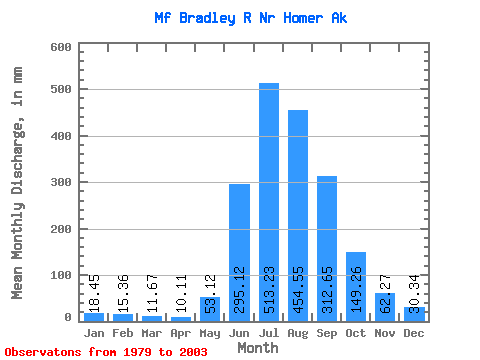
| Statistic | Jan | Feb | Mar | Apr | May | Jun | Jul | Aug | Sep | Oct | Nov | Dec | Annual |
|---|---|---|---|---|---|---|---|---|---|---|---|---|---|
| Mean | 18.49 | 15.53 | 11.65 | 10.14 | 53.08 | 295.10 | 513.16 | 454.46 | 312.70 | 149.26 | 62.28 | 30.37 | 1896.56 |
| Standard Deviation | 8.59 | 11.66 | 3.62 | 1.75 | 30.78 | 74.95 | 92.34 | 96.86 | 127.90 | 106.08 | 62.62 | 26.63 | 323.60 |
| Min | 12.01 | 8.20 | 4.11 | 7.24 | 17.17 | 136.24 | 349.92 | 273.55 | 117.76 | 49.02 | 16.10 | 14.02 | 1199.01 |
| Max | 53.59 | 65.80 | 22.58 | 13.44 | 140.02 | 493.48 | 693.95 | 643.11 | 671.03 | 451.89 | 322.73 | 117.84 | 2526.93 |
| Coefficient of Variation | 0.47 | 0.75 | 0.31 | 0.17 | 0.58 | 0.25 | 0.18 | 0.21 | 0.41 | 0.71 | 1.00 | 0.88 | 0.17 |
 Return to R-Arctic Net Home Page