|
|
|||||||||||||||||
| Point ID: 9453 | Downloads | Plots | Site Data | Code: 15276000 |
|
|
|||||||||||||||||
| Download | |
|---|---|
| Site Descriptor Information | Site Time Series Data |
| Link to all available data | |
| View: | Time Series | All |
| Units: | mm |
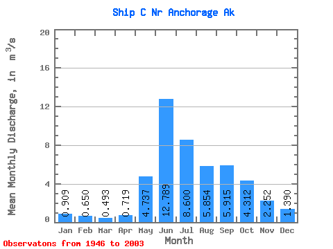
| Statistic | Jan | Feb | Mar | Apr | May | Jun | Jul | Aug | Sep | Oct | Nov | Dec | Annual |
|---|---|---|---|---|---|---|---|---|---|---|---|---|---|
| Mean | 0.91 | 0.65 | 0.49 | 0.72 | 4.74 | 12.79 | 8.60 | 5.85 | 5.92 | 4.31 | 2.25 | 1.39 | 4.06 |
| Standard Deviation | 0.44 | 0.32 | 0.28 | 0.38 | 2.37 | 3.82 | 3.44 | 2.60 | 2.54 | 2.00 | 0.97 | 0.63 | 0.90 |
| Min | 0.20 | 0.15 | 0.10 | 0.14 | 1.13 | 3.72 | 2.04 | 2.07 | 1.58 | 1.38 | 0.69 | 0.39 | 1.77 |
| Max | 2.25 | 1.75 | 1.42 | 1.97 | 12.91 | 22.60 | 18.27 | 14.45 | 13.35 | 10.09 | 5.63 | 4.36 | 6.38 |
| Coefficient of Variation | 0.48 | 0.50 | 0.58 | 0.52 | 0.50 | 0.30 | 0.40 | 0.44 | 0.43 | 0.46 | 0.43 | 0.46 | 0.22 |
 Return to R-Arctic Net Home Page