|
|
|||||||||||||||||
| Point ID: 9453 | Downloads | Plots | Site Data | Code: 15276000 |
|
|
|||||||||||||||||
| Download | |
|---|---|
| Site Descriptor Information | Site Time Series Data |
| Link to all available data | |
| View: | Time Series | All |
| Units: | m3/s |
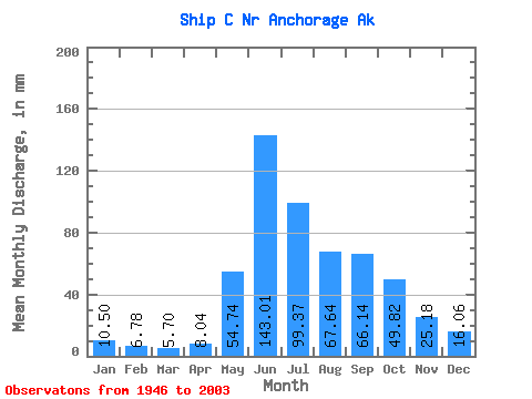
| Statistic | Jan | Feb | Mar | Apr | May | Jun | Jul | Aug | Sep | Oct | Nov | Dec | Annual |
|---|---|---|---|---|---|---|---|---|---|---|---|---|---|
| Mean | 10.51 | 6.84 | 5.70 | 8.04 | 54.72 | 143.00 | 99.36 | 67.64 | 66.14 | 49.82 | 25.18 | 16.06 | 553.14 |
| Standard Deviation | 5.08 | 3.40 | 3.29 | 4.20 | 27.36 | 42.69 | 39.74 | 29.99 | 28.36 | 23.09 | 10.82 | 7.33 | 122.82 |
| Min | 2.33 | 1.60 | 1.18 | 1.51 | 13.05 | 41.64 | 23.57 | 23.89 | 17.67 | 15.94 | 7.71 | 4.55 | 240.68 |
| Max | 25.96 | 18.36 | 16.41 | 22.06 | 149.19 | 252.75 | 211.09 | 166.92 | 149.25 | 116.56 | 62.92 | 50.34 | 868.47 |
| Coefficient of Variation | 0.48 | 0.50 | 0.58 | 0.52 | 0.50 | 0.30 | 0.40 | 0.44 | 0.43 | 0.46 | 0.43 | 0.46 | 0.22 |
 Return to R-Arctic Net Home Page