|
|
|||||||||||||||||
| Point ID: 9447 | Downloads | Plots | Site Data | Code: 15274300 |
|
|
|||||||||||||||||
| Download | |
|---|---|
| Site Descriptor Information | Site Time Series Data |
| Link to all available data | |
| View: | Time Series | All |
| Units: | mm |
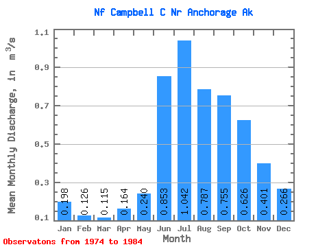
| Statistic | Jan | Feb | Mar | Apr | May | Jun | Jul | Aug | Sep | Oct | Nov | Dec | Annual |
|---|---|---|---|---|---|---|---|---|---|---|---|---|---|
| Mean | 0.20 | 0.13 | 0.12 | 0.16 | 0.24 | 0.85 | 1.04 | 0.79 | 0.76 | 0.63 | 0.40 | 0.27 | 0.49 |
| Standard Deviation | 0.05 | 0.05 | 0.04 | 0.05 | 0.08 | 0.18 | 0.31 | 0.32 | 0.29 | 0.24 | 0.14 | 0.08 | 0.11 |
| Min | 0.11 | 0.06 | 0.05 | 0.08 | 0.12 | 0.65 | 0.68 | 0.41 | 0.37 | 0.32 | 0.17 | 0.12 | 0.35 |
| Max | 0.27 | 0.22 | 0.17 | 0.25 | 0.39 | 1.14 | 1.58 | 1.43 | 1.27 | 1.03 | 0.60 | 0.38 | 0.67 |
| Coefficient of Variation | 0.26 | 0.40 | 0.32 | 0.33 | 0.35 | 0.21 | 0.30 | 0.41 | 0.39 | 0.39 | 0.36 | 0.30 | 0.23 |
 Return to R-Arctic Net Home Page