|
|
|||||||||||||||||
| Point ID: 9447 | Downloads | Plots | Site Data | Code: 15274300 |
|
|
|||||||||||||||||
| Download | |
|---|---|
| Site Descriptor Information | Site Time Series Data |
| Link to all available data | |
| View: | Time Series | All |
| Units: | m3/s |
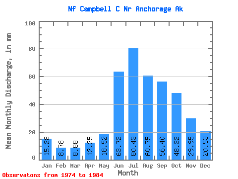
| Statistic | Jan | Feb | Mar | Apr | May | Jun | Jul | Aug | Sep | Oct | Nov | Dec | Annual |
|---|---|---|---|---|---|---|---|---|---|---|---|---|---|
| Mean | 15.32 | 8.88 | 8.86 | 12.22 | 18.53 | 63.69 | 80.38 | 60.71 | 56.38 | 48.35 | 29.93 | 20.54 | 445.66 |
| Standard Deviation | 3.98 | 3.52 | 2.82 | 3.96 | 6.46 | 13.11 | 23.86 | 24.56 | 22.07 | 18.65 | 10.67 | 6.12 | 100.32 |
| Min | 8.74 | 4.50 | 3.58 | 6.22 | 9.46 | 48.71 | 52.17 | 31.85 | 27.35 | 25.01 | 12.83 | 9.59 | 320.39 |
| Max | 20.97 | 15.65 | 13.26 | 18.67 | 30.01 | 85.17 | 121.71 | 110.04 | 95.19 | 79.31 | 44.70 | 29.25 | 605.61 |
| Coefficient of Variation | 0.26 | 0.40 | 0.32 | 0.33 | 0.35 | 0.21 | 0.30 | 0.41 | 0.39 | 0.39 | 0.36 | 0.30 | 0.23 |
 Return to R-Arctic Net Home Page