|
|
|||||||||||||||||
| Point ID: 9440 | Downloads | Plots | Site Data | Code: 15272550 |
|
|
|||||||||||||||||
| Download | |
|---|---|
| Site Descriptor Information | Site Time Series Data |
| Link to all available data | |
| View: | Time Series | All |
| Units: | mm |
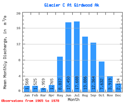
| Statistic | Jan | Feb | Mar | Apr | May | Jun | Jul | Aug | Sep | Oct | Nov | Dec | Annual |
|---|---|---|---|---|---|---|---|---|---|---|---|---|---|
| Mean | 1.57 | 1.52 | 0.96 | 1.77 | 8.84 | 17.45 | 17.69 | 13.89 | 12.36 | 7.63 | 3.92 | 2.13 | 7.46 |
| Standard Deviation | 1.52 | 1.64 | 0.71 | 0.72 | 2.49 | 3.96 | 4.12 | 5.15 | 6.59 | 5.08 | 2.97 | 2.25 | 1.67 |
| Min | 0.60 | 0.44 | 0.40 | 0.38 | 4.30 | 10.90 | 11.95 | 7.76 | 4.72 | 2.81 | 0.89 | 0.97 | 4.88 |
| Max | 5.59 | 5.75 | 2.76 | 2.76 | 12.84 | 24.06 | 26.31 | 25.49 | 27.63 | 23.15 | 11.85 | 8.74 | 9.76 |
| Coefficient of Variation | 0.97 | 1.07 | 0.74 | 0.41 | 0.28 | 0.23 | 0.23 | 0.37 | 0.53 | 0.67 | 0.76 | 1.05 | 0.22 |
 Return to R-Arctic Net Home Page