|
|
|||||||||||||||||
| Point ID: 9440 | Downloads | Plots | Site Data | Code: 15272550 |
|
|
|||||||||||||||||
| Download | |
|---|---|
| Site Descriptor Information | Site Time Series Data |
| Link to all available data | |
| View: | Time Series | All |
| Units: | m3/s |
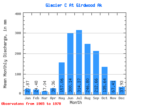
| Statistic | Jan | Feb | Mar | Apr | May | Jun | Jul | Aug | Sep | Oct | Nov | Dec | Annual |
|---|---|---|---|---|---|---|---|---|---|---|---|---|---|
| Mean | 27.87 | 24.69 | 17.04 | 30.35 | 157.03 | 300.13 | 314.31 | 246.76 | 212.66 | 135.63 | 67.40 | 37.93 | 1561.35 |
| Standard Deviation | 27.01 | 26.48 | 12.65 | 12.38 | 44.26 | 68.09 | 73.24 | 91.59 | 113.37 | 90.20 | 51.07 | 40.00 | 350.07 |
| Min | 10.70 | 7.18 | 7.17 | 6.54 | 76.45 | 187.43 | 212.28 | 137.88 | 81.11 | 50.01 | 15.33 | 17.24 | 1022.57 |
| Max | 99.39 | 93.10 | 48.97 | 47.42 | 228.15 | 413.89 | 467.57 | 452.96 | 475.22 | 411.31 | 203.83 | 155.26 | 2043.97 |
| Coefficient of Variation | 0.97 | 1.07 | 0.74 | 0.41 | 0.28 | 0.23 | 0.23 | 0.37 | 0.53 | 0.67 | 0.76 | 1.05 | 0.22 |
 Return to R-Arctic Net Home Page