|
|
|||||||||||||||||
| Point ID: 9438 | Downloads | Plots | Site Data | Code: 15272280 |
|
|
|||||||||||||||||
| Download | |
|---|---|
| Site Descriptor Information | Site Time Series Data |
| Link to all available data | |
| View: | Time Series | All |
| Units: | mm |
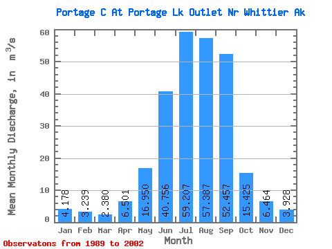
| Statistic | Jan | Feb | Mar | Apr | May | Jun | Jul | Aug | Sep | Oct | Nov | Dec | Annual |
|---|---|---|---|---|---|---|---|---|---|---|---|---|---|
| Mean | 4.18 | 3.24 | 2.38 | 6.50 | 16.95 | 40.76 | 59.21 | 57.39 | 52.46 | 15.43 | 6.46 | 3.93 | 22.17 |
| Standard Deviation | 3.94 | 2.18 | 1.44 | 2.92 | 6.88 | 4.53 | 6.79 | 13.69 | 20.41 | 7.14 | 3.99 | 2.56 | 2.34 |
| Min | 0.74 | 0.74 | 0.74 | 1.04 | 8.11 | 33.36 | 48.53 | 39.89 | 18.38 | 3.85 | 2.56 | 0.74 | 18.36 |
| Max | 13.02 | 7.84 | 5.35 | 11.13 | 32.80 | 48.94 | 71.30 | 89.60 | 101.45 | 28.72 | 15.66 | 9.09 | 27.20 |
| Coefficient of Variation | 0.94 | 0.67 | 0.60 | 0.45 | 0.41 | 0.11 | 0.12 | 0.24 | 0.39 | 0.46 | 0.62 | 0.65 | 0.11 |
 Return to R-Arctic Net Home Page