|
|
|||||||||||||||||
| Point ID: 9438 | Downloads | Plots | Site Data | Code: 15272280 |
|
|
|||||||||||||||||
| Download | |
|---|---|
| Site Descriptor Information | Site Time Series Data |
| Link to all available data | |
| View: | Time Series | All |
| Units: | m3/s |
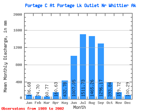
| Statistic | Jan | Feb | Mar | Apr | May | Jun | Jul | Aug | Sep | Oct | Nov | Dec | Annual |
|---|---|---|---|---|---|---|---|---|---|---|---|---|---|
| Mean | 106.67 | 75.35 | 60.76 | 160.63 | 432.72 | 1007.05 | 1511.49 | 1465.03 | 1296.16 | 393.80 | 159.73 | 100.28 | 6669.48 |
| Standard Deviation | 100.59 | 50.71 | 36.67 | 72.19 | 175.60 | 111.92 | 173.41 | 349.43 | 504.30 | 182.26 | 98.54 | 65.40 | 704.98 |
| Min | 18.79 | 17.12 | 18.79 | 25.66 | 207.10 | 824.37 | 1238.98 | 1018.41 | 454.09 | 98.22 | 63.30 | 18.98 | 5523.10 |
| Max | 332.26 | 182.28 | 136.63 | 275.09 | 837.40 | 1209.30 | 1820.10 | 2287.41 | 2506.73 | 733.14 | 386.93 | 232.14 | 8183.91 |
| Coefficient of Variation | 0.94 | 0.67 | 0.60 | 0.45 | 0.41 | 0.11 | 0.12 | 0.24 | 0.39 | 0.46 | 0.62 | 0.65 | 0.11 |
 Return to R-Arctic Net Home Page