|
|
|||||||||||||||||
| Point ID: 9416 | Downloads | Plots | Site Data | Code: 15514500 |
|
|
|||||||||||||||||
| Download | |
|---|---|
| Site Descriptor Information | Site Time Series Data |
| Link to all available data | |
| View: | Time Series | All |
| Units: | mm |
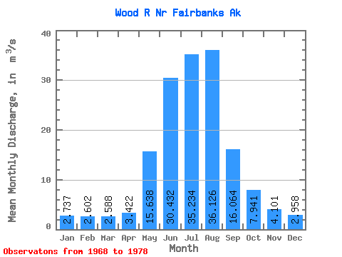
| Statistic | Jan | Feb | Mar | Apr | May | Jun | Jul | Aug | Sep | Oct | Nov | Dec | Annual |
|---|---|---|---|---|---|---|---|---|---|---|---|---|---|
| Mean | 2.74 | 2.60 | 2.59 | 3.42 | 15.64 | 30.43 | 35.23 | 36.13 | 16.06 | 7.94 | 4.10 | 2.96 | 13.27 |
| Standard Deviation | 0.83 | 0.86 | 0.81 | 1.06 | 4.82 | 9.71 | 5.15 | 9.92 | 4.16 | 1.82 | 1.28 | 0.91 | 2.04 |
| Min | 1.42 | 1.42 | 1.42 | 1.67 | 7.35 | 21.06 | 29.89 | 22.80 | 10.11 | 5.12 | 2.03 | 1.51 | 10.67 |
| Max | 3.81 | 3.68 | 3.75 | 4.77 | 21.66 | 52.39 | 46.80 | 57.05 | 23.62 | 11.23 | 6.01 | 4.53 | 18.31 |
| Coefficient of Variation | 0.30 | 0.33 | 0.31 | 0.31 | 0.31 | 0.32 | 0.15 | 0.28 | 0.26 | 0.23 | 0.31 | 0.31 | 0.15 |
 Return to R-Arctic Net Home Page