|
|
|||||||||||||||||
| Point ID: 9416 | Downloads | Plots | Site Data | Code: 15514500 |
|
|
|||||||||||||||||
| Download | |
|---|---|
| Site Descriptor Information | Site Time Series Data |
| Link to all available data | |
| View: | Time Series | All |
| Units: | m3/s |
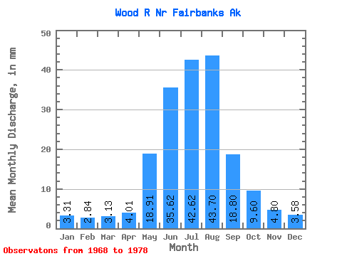
| Statistic | Jan | Feb | Mar | Apr | May | Jun | Jul | Aug | Sep | Oct | Nov | Dec | Annual |
|---|---|---|---|---|---|---|---|---|---|---|---|---|---|
| Mean | 3.31 | 2.87 | 3.13 | 4.01 | 18.91 | 35.62 | 42.61 | 43.69 | 18.80 | 9.60 | 4.80 | 3.58 | 189.13 |
| Standard Deviation | 1.01 | 0.95 | 0.97 | 1.24 | 5.83 | 11.37 | 6.23 | 12.00 | 4.86 | 2.21 | 1.50 | 1.10 | 29.04 |
| Min | 1.71 | 1.56 | 1.71 | 1.95 | 8.89 | 24.65 | 36.14 | 27.58 | 11.83 | 6.19 | 2.38 | 1.82 | 152.13 |
| Max | 4.61 | 4.06 | 4.53 | 5.58 | 26.19 | 61.32 | 56.60 | 68.99 | 27.64 | 13.58 | 7.04 | 5.48 | 261.00 |
| Coefficient of Variation | 0.30 | 0.33 | 0.31 | 0.31 | 0.31 | 0.32 | 0.15 | 0.28 | 0.26 | 0.23 | 0.31 | 0.31 | 0.15 |
 Return to R-Arctic Net Home Page