|
|
|||||||||||||||||
| Point ID: 9401 | Downloads | Plots | Site Data | Code: 15906000 |
|
|
|||||||||||||||||
| Download | |
|---|---|
| Site Descriptor Information | Site Time Series Data |
| Link to all available data | |
| View: | Time Series | All |
| Units: | mm |
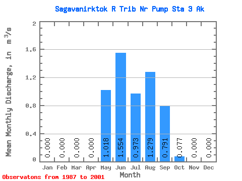
| Statistic | Jan | Feb | Mar | Apr | May | Jun | Jul | Aug | Sep | Oct | Nov | Dec | Annual |
|---|---|---|---|---|---|---|---|---|---|---|---|---|---|
| Mean | 0.00 | 0.00 | 0.00 | 0.00 | 1.02 | 1.55 | 0.97 | 1.28 | 0.79 | 0.08 | 0.00 | 0.00 | 0.51 |
| Standard Deviation | 0.00 | 0.00 | 0.00 | 0.00 | 0.88 | 1.04 | 0.66 | 0.58 | 0.50 | 0.06 | 0.00 | 0.00 | 0.17 |
| Min | 0.00 | 0.00 | 0.00 | 0.00 | 0.00 | 0.29 | 0.23 | 0.09 | 0.27 | 0.00 | 0.00 | 0.00 | 0.22 |
| Max | 0.00 | 0.00 | 0.00 | 0.00 | 2.71 | 4.24 | 2.31 | 2.57 | 2.19 | 0.19 | 0.00 | 0.00 | 0.79 |
| Coefficient of Variation | 0.87 | 0.67 | 0.67 | 0.46 | 0.63 | 0.77 | 0.33 |
 Return to R-Arctic Net Home Page