|
|
|||||||||||||||||
| Point ID: 9401 | Downloads | Plots | Site Data | Code: 15906000 |
|
|
|||||||||||||||||
| Download | |
|---|---|
| Site Descriptor Information | Site Time Series Data |
| Link to all available data | |
| View: | Time Series | All |
| Units: | m3/s |
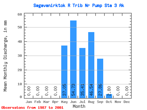
| Statistic | Jan | Feb | Mar | Apr | May | Jun | Jul | Aug | Sep | Oct | Nov | Dec | Annual |
|---|---|---|---|---|---|---|---|---|---|---|---|---|---|
| Mean | 0.00 | 0.00 | 0.00 | 0.00 | 37.06 | 54.73 | 35.41 | 46.54 | 27.84 | 2.81 | 0.00 | 0.00 | 219.62 |
| Standard Deviation | 0.00 | 0.00 | 0.00 | 0.00 | 32.11 | 36.76 | 23.88 | 21.27 | 17.59 | 2.17 | 0.00 | 0.00 | 72.53 |
| Min | 0.00 | 0.00 | 0.00 | 0.00 | 0.03 | 10.33 | 8.44 | 3.26 | 9.53 | 0.00 | 0.00 | 0.00 | 94.71 |
| Max | 0.00 | 0.00 | 0.00 | 0.00 | 98.55 | 149.19 | 84.05 | 93.53 | 77.19 | 7.04 | 0.00 | 0.00 | 339.93 |
| Coefficient of Variation | 0.87 | 0.67 | 0.67 | 0.46 | 0.63 | 0.77 | 0.33 |
 Return to R-Arctic Net Home Page