|
|
|||||||||||||||||
| Point ID: 94 | Downloads | Plots | Site Data | Code: 05AD016 |
|
|
|||||||||||||||||
| Download | |
|---|---|
| Site Descriptor Information | Site Time Series Data |
| Link to all available data | |
| View: | Time Series | All |
| Units: | mm |
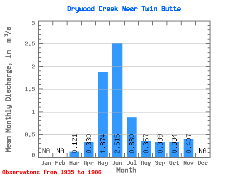
| Statistic | Jan | Feb | Mar | Apr | May | Jun | Jul | Aug | Sep | Oct | Nov | Dec | Annual |
|---|---|---|---|---|---|---|---|---|---|---|---|---|---|
| Mean | 0.12 | 0.33 | 1.87 | 2.52 | 0.88 | 0.36 | 0.34 | 0.33 | 0.41 | ||||
| Standard Deviation | 0.04 | 0.17 | 0.64 | 1.12 | 0.47 | 0.20 | 0.30 | 0.25 | |||||
| Min | 0.05 | 0.08 | 0.57 | 0.53 | 0.22 | 0.17 | 0.11 | 0.11 | 0.41 | ||||
| Max | 0.20 | 0.77 | 3.48 | 5.92 | 2.60 | 1.16 | 1.70 | 1.03 | 0.41 | ||||
| Coefficient of Variation | 0.37 | 0.52 | 0.34 | 0.44 | 0.53 | 0.57 | 0.87 | 0.75 |
 Return to R-Arctic Net Home Page