|
|
|||||||||||||||||
| Point ID: 94 | Downloads | Plots | Site Data | Code: 05AD016 |
|
|
|||||||||||||||||
| Download | |
|---|---|
| Site Descriptor Information | Site Time Series Data |
| Link to all available data | |
| View: | Time Series | All |
| Units: | m3/s |
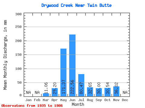
| Statistic | Jan | Feb | Mar | Apr | May | Jun | Jul | Aug | Sep | Oct | Nov | Dec | Annual |
|---|---|---|---|---|---|---|---|---|---|---|---|---|---|
| Mean | 11.02 | 29.20 | 171.38 | 222.59 | 80.43 | 32.63 | 30.04 | 30.57 | 36.02 | ||||
| Standard Deviation | 4.08 | 15.16 | 58.91 | 98.82 | 42.89 | 18.65 | 26.25 | 22.81 | |||||
| Min | 4.85 | 7.17 | 51.93 | 46.73 | 19.75 | 15.09 | 10.00 | 9.78 | 36.02 | ||||
| Max | 18.56 | 68.23 | 318.18 | 523.89 | 237.72 | 106.06 | 150.44 | 94.17 | 36.02 | ||||
| Coefficient of Variation | 0.37 | 0.52 | 0.34 | 0.44 | 0.53 | 0.57 | 0.87 | 0.75 |
 Return to R-Arctic Net Home Page