|
|
|||||||||||||||||
| Point ID: 9398 | Downloads | Plots | Site Data | Code: 15896700 |
|
|
|||||||||||||||||
| Download | |
|---|---|
| Site Descriptor Information | Site Time Series Data |
| Link to all available data | |
| View: | Time Series | All |
| Units: | mm |
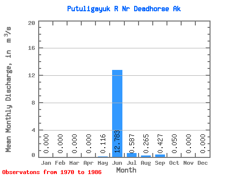
| Statistic | Jan | Feb | Mar | Apr | May | Jun | Jul | Aug | Sep | Oct | Nov | Dec | Annual |
|---|---|---|---|---|---|---|---|---|---|---|---|---|---|
| Mean | 0.00 | 0.00 | 0.00 | 0.00 | 0.12 | 12.78 | 0.59 | 0.27 | 0.43 | 0.05 | 0.00 | 0.00 | 1.21 |
| Standard Deviation | 0.00 | 0.00 | 0.00 | 0.00 | 0.39 | 4.49 | 0.47 | 0.37 | 0.55 | 0.12 | 0.00 | 0.00 | 0.31 |
| Min | 0.00 | 0.00 | 0.00 | 0.00 | 0.00 | 4.62 | 0.09 | 0.00 | 0.01 | 0.00 | 0.00 | 0.00 | 0.77 |
| Max | 0.00 | 0.00 | 0.00 | 0.00 | 1.52 | 19.66 | 1.80 | 1.39 | 1.75 | 0.43 | 0.00 | 0.00 | 1.69 |
| Coefficient of Variation | 3.35 | 0.35 | 0.81 | 1.39 | 1.30 | 2.29 | 0.26 |
 Return to R-Arctic Net Home Page