|
|
|||||||||||||||||
| Point ID: 9398 | Downloads | Plots | Site Data | Code: 15896700 |
|
|
|||||||||||||||||
| Download | |
|---|---|
| Site Descriptor Information | Site Time Series Data |
| Link to all available data | |
| View: | Time Series | All |
| Units: | m3/s |
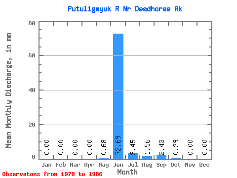
| Statistic | Jan | Feb | Mar | Apr | May | Jun | Jul | Aug | Sep | Oct | Nov | Dec | Annual |
|---|---|---|---|---|---|---|---|---|---|---|---|---|---|
| Mean | 0.00 | 0.00 | 0.00 | 0.00 | 0.68 | 72.70 | 3.45 | 1.56 | 2.43 | 0.29 | 0.00 | 0.00 | 83.80 |
| Standard Deviation | 0.00 | 0.00 | 0.00 | 0.00 | 2.28 | 25.52 | 2.77 | 2.16 | 3.15 | 0.68 | 0.00 | 0.00 | 21.63 |
| Min | 0.00 | 0.00 | 0.00 | 0.00 | 0.00 | 26.30 | 0.55 | 0.02 | 0.06 | 0.00 | 0.00 | 0.00 | 53.40 |
| Max | 0.00 | 0.00 | 0.00 | 0.00 | 8.90 | 111.79 | 10.60 | 8.14 | 9.97 | 2.51 | 0.00 | 0.00 | 117.16 |
| Coefficient of Variation | 3.35 | 0.35 | 0.81 | 1.39 | 1.30 | 2.29 | 0.26 |
 Return to R-Arctic Net Home Page