|
|
|||||||||||||||||
| Point ID: 9385 | Downloads | Plots | Site Data | Code: 15743850 |
|
|
|||||||||||||||||
| Download | |
|---|---|
| Site Descriptor Information | Site Time Series Data |
| Link to all available data | |
| View: | Time Series | All |
| Units: | mm |
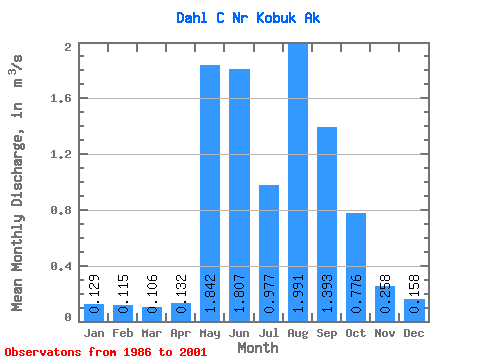
| Statistic | Jan | Feb | Mar | Apr | May | Jun | Jul | Aug | Sep | Oct | Nov | Dec | Annual |
|---|---|---|---|---|---|---|---|---|---|---|---|---|---|
| Mean | 0.13 | 0.12 | 0.11 | 0.13 | 1.84 | 1.81 | 0.98 | 1.99 | 1.39 | 0.78 | 0.26 | 0.16 | 0.67 |
| Standard Deviation | 0.05 | 0.04 | 0.04 | 0.07 | 1.13 | 0.93 | 0.51 | 1.46 | 0.73 | 0.46 | 0.10 | 0.06 | 0.26 |
| Min | 0.06 | 0.06 | 0.05 | 0.04 | 0.18 | 0.37 | 0.30 | 0.49 | 0.56 | 0.27 | 0.10 | 0.07 | 0.45 |
| Max | 0.20 | 0.17 | 0.16 | 0.23 | 3.94 | 3.27 | 2.07 | 6.31 | 2.95 | 1.90 | 0.45 | 0.23 | 1.05 |
| Coefficient of Variation | 0.37 | 0.37 | 0.40 | 0.50 | 0.61 | 0.51 | 0.52 | 0.73 | 0.52 | 0.59 | 0.40 | 0.37 | 0.39 |
 Return to R-Arctic Net Home Page