|
|
|||||||||||||||||
| Point ID: 9385 | Downloads | Plots | Site Data | Code: 15743850 |
|
|
|||||||||||||||||
| Download | |
|---|---|
| Site Descriptor Information | Site Time Series Data |
| Link to all available data | |
| View: | Time Series | All |
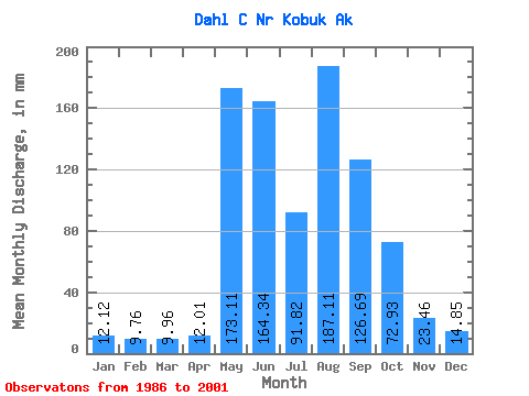
| Units: | m3/s |
| Statistic | Jan | Feb | Mar | Apr | May | Jun | Jul | Aug | Sep | Oct | Nov | Dec | Annual |
|---|---|---|---|---|---|---|---|---|---|---|---|---|---|
| Mean | 12.07 | 9.87 | 10.01 | 12.00 | 173.04 | 164.35 | 91.76 | 187.04 | 126.70 | 72.88 | 23.49 | 14.88 | 739.47 |
| Standard Deviation | 4.42 | 3.68 | 4.03 | 5.97 | 106.31 | 84.35 | 47.49 | 136.72 | 66.21 | 42.99 | 9.27 | 5.49 | 289.59 |
| Min | 5.36 | 4.88 | 4.31 | 3.82 | 16.53 | 33.67 | 28.10 | 46.01 | 50.91 | 25.67 | 9.53 | 6.80 | 495.60 |
| Max | 18.31 | 14.92 | 15.00 | 20.87 | 370.73 | 297.71 | 194.69 | 593.19 | 268.70 | 178.71 | 41.20 | 21.76 | 1159.44 |
| Coefficient of Variation | 0.37 | 0.37 | 0.40 | 0.50 | 0.61 | 0.51 | 0.52 | 0.73 | 0.52 | 0.59 | 0.40 | 0.37 | 0.39 |
 Return to R-Arctic Net Home Page