|
|
|||||||||||||||||
| Point ID: 9383 | Downloads | Plots | Site Data | Code: 15712000 |
|
|
|||||||||||||||||
| Download | |
|---|---|
| Site Descriptor Information | Site Time Series Data |
| Link to all available data | |
| View: | Time Series | All |
| Units: | mm |
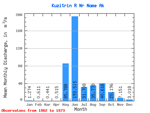
| Statistic | Jan | Feb | Mar | Apr | May | Jun | Jul | Aug | Sep | Oct | Nov | Dec | Annual |
|---|---|---|---|---|---|---|---|---|---|---|---|---|---|
| Mean | 1.27 | 0.61 | 0.44 | 0.52 | 85.79 | 193.51 | 31.71 | 35.78 | 40.62 | 20.20 | 7.15 | 3.02 | 33.83 |
| Standard Deviation | 1.35 | 1.05 | 0.92 | 0.85 | 76.93 | 103.33 | 16.52 | 34.20 | 37.17 | 11.05 | 3.63 | 1.38 | 9.74 |
| Min | 0.06 | 0.00 | 0.00 | 0.00 | 5.99 | 25.82 | 9.81 | 10.19 | 10.78 | 5.30 | 2.35 | 0.66 | 15.53 |
| Max | 4.02 | 3.05 | 2.45 | 2.27 | 233.66 | 333.95 | 52.98 | 116.81 | 117.63 | 38.40 | 12.70 | 6.01 | 45.46 |
| Coefficient of Variation | 1.06 | 1.73 | 2.08 | 1.65 | 0.90 | 0.53 | 0.52 | 0.96 | 0.92 | 0.55 | 0.51 | 0.46 | 0.29 |
 Return to R-Arctic Net Home Page