|
|
|||||||||||||||||
| Point ID: 9383 | Downloads | Plots | Site Data | Code: 15712000 |
|
|
|||||||||||||||||
| Download | |
|---|---|
| Site Descriptor Information | Site Time Series Data |
| Link to all available data | |
| View: | Time Series | All |
| Units: | m3/s |
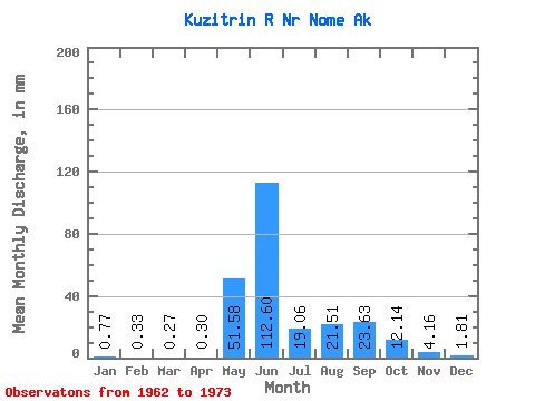
| Statistic | Jan | Feb | Mar | Apr | May | Jun | Jul | Aug | Sep | Oct | Nov | Dec | Annual |
|---|---|---|---|---|---|---|---|---|---|---|---|---|---|
| Mean | 0.77 | 0.34 | 0.27 | 0.30 | 51.57 | 112.59 | 19.06 | 21.51 | 23.63 | 12.14 | 4.16 | 1.81 | 239.68 |
| Standard Deviation | 0.81 | 0.58 | 0.55 | 0.49 | 46.25 | 60.12 | 9.93 | 20.56 | 21.63 | 6.64 | 2.11 | 0.83 | 68.99 |
| Min | 0.03 | 0.00 | 0.00 | 0.00 | 3.60 | 15.02 | 5.89 | 6.13 | 6.27 | 3.19 | 1.37 | 0.40 | 110.01 |
| Max | 2.42 | 1.67 | 1.47 | 1.32 | 140.47 | 194.31 | 31.85 | 70.22 | 68.44 | 23.09 | 7.39 | 3.61 | 322.05 |
| Coefficient of Variation | 1.06 | 1.73 | 2.08 | 1.65 | 0.90 | 0.53 | 0.52 | 0.96 | 0.92 | 0.55 | 0.51 | 0.46 | 0.29 |
 Return to R-Arctic Net Home Page